Our Services

Multi-Criteria Site Selection Studies
We provide comprehensive multi-criteria site selection studies and regional spatial analysis, leveraging advanced mapping and data-driven methodologies to evaluate and compare multiple locations. By integrating diverse place evaluation criteria—such as accessibility, land use compatibility, environmental impact, infrastructure readiness, and socio-economic factors—we deliver actionable insights that guide informed decision-making. Our approach combines GIS-based spatial analysis with customized evaluation frameworks to identify optimal sites that align with project goals and strategic priorities.
This robust methodology enables stakeholders to assess the relative strengths and limitations of each site, ensuring that final selections are not only data-supported but also tailored to the unique requirements of the project and the regional context.


Advanced Collaboration
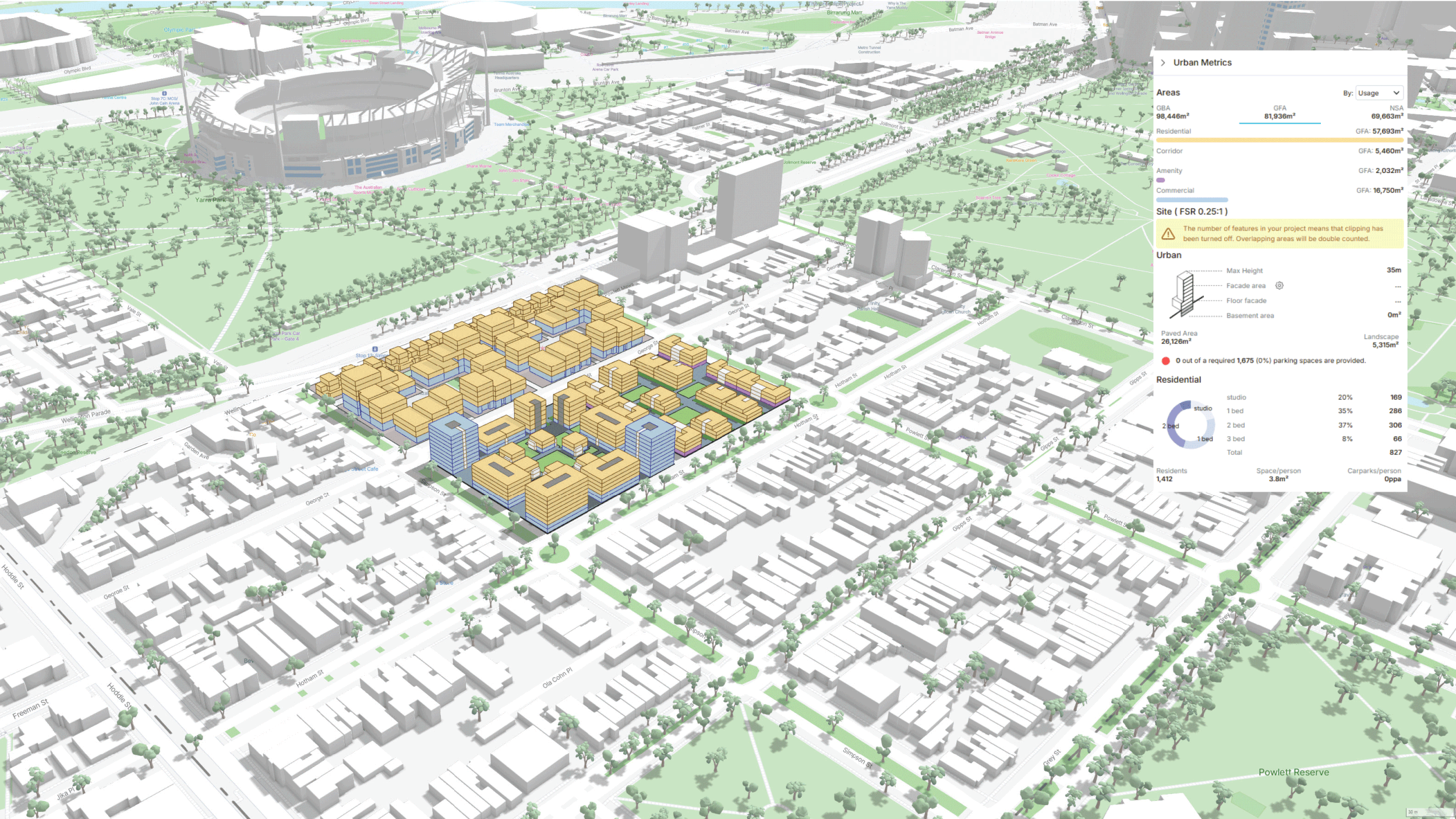
By integrating interactive data visualization platforms, we transform complex spatial and urban data into intuitive visual formats that support shared understanding and informed decision-making.
We use tools to empower teams, by exploring design scenarios, assess impacts, and refine concepts collaboratively in real time.
Our approach ensures that iterative feedback loops are efficient and transparent, reducing delays and enhancing the quality of outcomes.


Parametric Urban Design
Real-Time Data Integration: By harnessing real-time environmental and spatial data, we empower municipalities and developers to make informed decisions that balance growth with ecological preservation.
Scenario Modelling for Resilience: Our parametric design tools allow for rapid exploration of multiple design scenarios.
+Data integrated design libraries
+Rapid scenario/iterative processes for precision modeling
+Sustainability-focused outcomes
+Parametric design enabled mapping
+Collaborative, client-driven process


Local Context Site Assessments
Our expertise in multi-criteria site assessment within city contexts enables us to deliver comprehensive evaluations of urban sites, focusing on walkability, access to essential services, real-estate values, and livable neighbourhood principles.
We specialize in rapidly collecting and analyzing urban data, evaluating multiple sites based on attributes such as connectivity, proximity to amenities, and the availability of services within walking distance.
By integrating open-source data and real-estate market information—such as vacant properties, rental prices, and market trends from listing platforms—we provide a holistic understanding of a site’s value and potential. This data is spatially mapped and analyzed using advanced AI-driven mapping and analysis tools, ensuring precise, actionable insights.


